Saturday, July 20, 2013

Farewell to the West Coast and final thoughts

Sunday, June 2, 2012

 Last night James disassembled our bikes, packed them and our other gear into the bike boxes our host (and owner of Bike Flights) had given us and we left them in the Bike Flight office. The owner was kind enough to get up at 4:30 am to take us to the airport for our early morning departure.  He printed out the labels he had in his records and had Fed Ex pick them up on Monday.   I must give a huge thanks to Bill and his family for their wonderful hospitality.

This was the first day that we hadn't ridden our bikes in two weeks.  It felt strange to walk with a couple of small bags as we went to our gate at the airport.  While we were on our tour we didn't keep up with the news going on in the country or in the world.  We picked up a newspaper and learned that Doc Watson, a favorite folk music artist had passed away.  We were sad to learn the news.  I must say that it was nice to have 2 weeks away from all of the media hype which is either fear inducing or pointless information about the lives of Hollywood TV and film stars -- that I didn't miss.

I can definitely say that I'm hooked on touring and we have plans to have additional adventures on our touring bikes.  It forces one to slow down and observe the world around them as they are going to their destination.  I love the sensory aspect -- not only do you get the sights, but the sounds and smells add to the experience.  We met very friendly people and it seemed that traveling by bicycle opened up conversations that would not have been attempted had we been in a car.  The final aspect that I found attractive was the simplicity of the whole experience.  The bicycle in itself is a simple machine and to carry one's belongings forces one to narrow down the material items to the basic needs.  This in itself simplifies life.

We were very fortunate not to have any major breakdowns or crises while we were on our bike tour.  I give James a lot of credit for this and some of it was luck.  James did a great job making sure he had our bikes set up correctly, studied the equipment and purchased the equipment that he felt would deter a lot of mechanical problems.  I have what we used in the first blog post if anyone who is reading and considering doing a bike tour needs additional details.

What we did that worked

I wanted to provide a brief summary of what we did to prepare for this tour and what we discovered while on our tour that worked for us.

  1. Shipping our bikes to San Francisco, CA and back home using BikeFlights was a great first step.  We got a great rate, great customer service, and it was much better than having to deal with the bikes at the airport. The owner is a cyclist and has previous experience working with the airline industry so he gets both sides.
  2. Doing a practice run two weeks before the tour so we could make adaptations to the bikes and gear before we left.
  3. Using waterproof panniers - I recommend the Ortlieb's.  We spent  a little more and bought the type that fold down and have pockets on the side rather than the "roll-down" type. We were able to put our high frequency used items in the outside pockets (maps) so they were readily accessible.
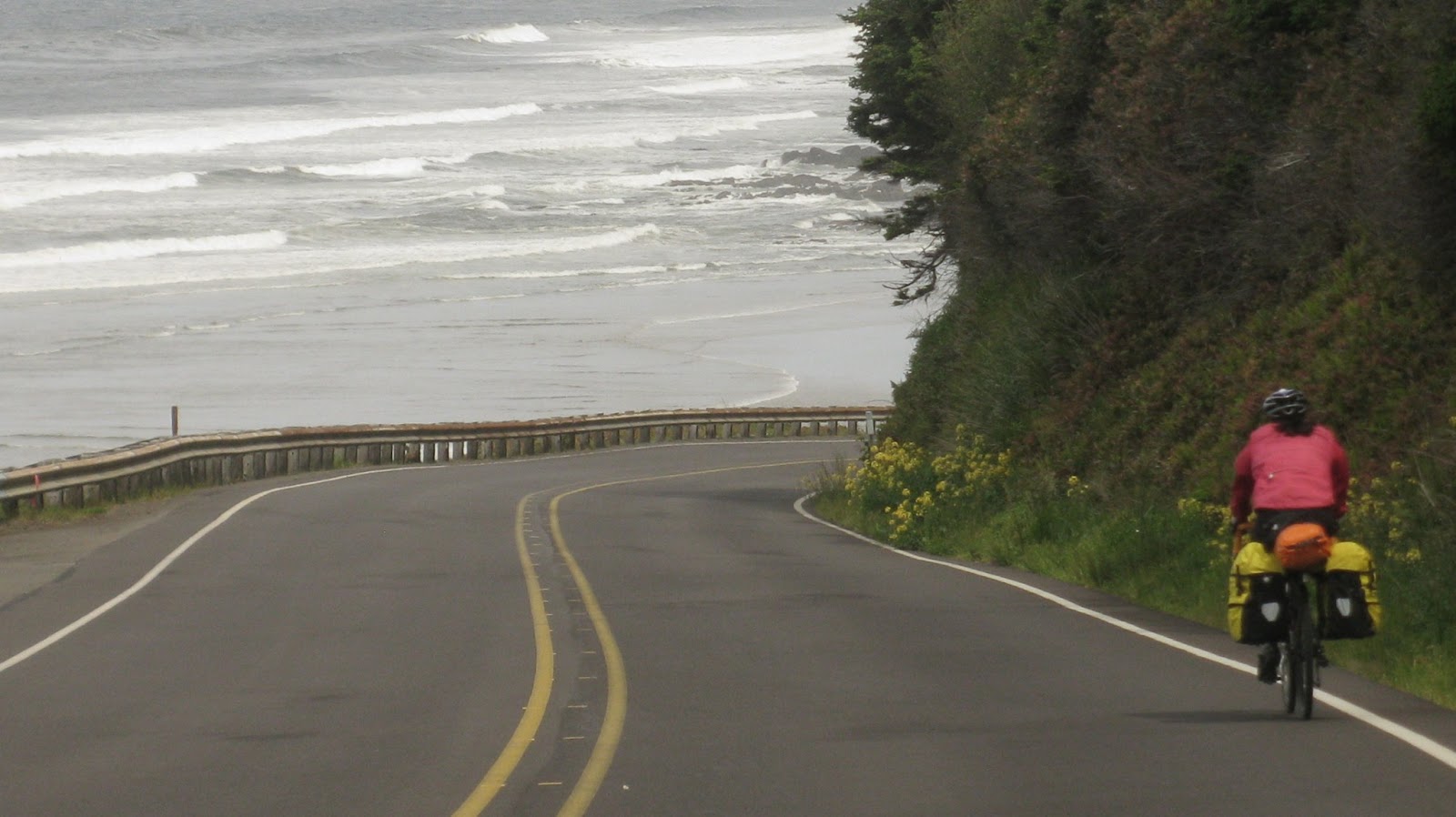
  4. Found as many alternate routes to Hwy 101 as we could.  It was extremely busy and it was nice to get on a side road with less traffic.  Keep in mind that a lot of times those routes will have more terrain but we were ok with it.  I recommend the steps I outlined below for any bike tour. 
    • Use the Cycling Adventures map as a starting point and then read the blogs and forums on their website.
    • Get on Google maps and use the "google map" guy to get a view of the roads to see if they had a shoulder.
    • Look at the "traffic density (or volume)" information for the roads you will travel (I know this is available for each state in America, I'm not sure about other countries).  This information is posted on most Department of Transportation for each state's website. If the highway listed on the Adventure Cycling route was reported as high traffic density try to find an alternate road with less traffic volume.
    • Bring physical maps with you and don't rely on the GPS on your phone.  It is difficult to get an accurate view of the "big picture" of an area.  We used pages from the Gazetteer for the areas we were in.  He cut them out of the book so we had them for a reference.  These maps have all of the back roads and terrain information and have maps for each state.  You can buy them from Amazon.com or your local Wal-Mart or Target (keep in mind they will only have the states that the store is located in).
    • Once you are in the area, look for maps made by locals for the area (like the Krebs Cycle map we found).  Some are great, some aren't worth buying, you have to make that decision.
    • Talk to individual's working in bicycle shops.  Some are better than others.
  5. If you do this tour in the spring - take wool long underwear, 2 to 3 pairs of wool socks, and a wool base layer to sleep in at night.  You will also want a stocking cap.  It gets chilly once the sun goes down on the coast.
  6. I'd only take one sleeveless jersey (or none) and take 2 long sleeve synthetic shirts.  I found myself wearing the shirt I bought in Eureka, OR each day.  Rain gear is necessary too.
  7. If you can't eat a big breakfast when you wake up, trying eating a small one and then waiting until you reach the a town 30 min -1.5 hours later to stop to eat breakfast at restaurant.  It worked well for me.  I had developed an appetite and could eat a lot more food that carried me through the day.
  8. Allow yourself to have rest days -- especially if your body is telling you that you need to give it some rest.
  9. One thing we didn't do was allow ourselves to spend more than one day in a spot.  There were a couple of places that I would have liked to have had more time to explore the area.
  10. If your tour is during a holiday - if possible, I recommend staying put during the day that everyone is traveling to or from the destination spot if you are unable to find an alternate route.
I hope you find this information useful and maybe this blog has inspired you to try bike touring.  I highly recommend it!  It was a lot of fun.

When ever we take our next bike tour, I'll post a blog about that experience.  Happy riding!

Friday, July 19, 2013

Beer Tour in Downtown Portland

Saturday, June 1, 2012

Our host gave us directions to get to downtown Portland and we got on our unloaded bikes and headed into town.  It is very strange riding an unloaded bike after carrying around 40-50 pounds for two weeks.  The bike wobbles and is hard to keep straight.

Portland has a fantastic biking system and a lot of people get around by bike.  They have designated bikeway system that dedicates certain roads for cyclists to keep them out of the high traffic areas as much as possible.  In fact, at 5 pm we saw the bicycle rush hour.  They have all of this information detailed in maps as well as signed on the roads.


Our priority was to ride to a local microbrew to reward ourselves with a job well done. We asked a few people and were guided to Rock Bottom Brewery.  We had a beer and ordered lunch.  We then decided it would be fun to find other microbrews for a "mini-microbrew tour" and that gave us our goal for the day.


Our next stop was Deschutes  Brewery.  The decor was impressive and they had a nice porter.  We ended up splitting that beer to make sure we could get to the next stop.


We visited some local bike shops, outdoor stores, and stopped to take a picture by the river.  We also hit the bicycle "rush hour" -- so cool!  We then made it to our final craft beer destination, Cascades Brewing Barrel House.  They specialized in sour beers and they were very good.  It was our favorite stop of the day.  When writing this post I learned that Portland as a "Breweries Map".  If we had a smartphone, it would have been a useful feature to help us on our adventure!


We made contact with the bike tourer we met on our first night and rode to his house to talk about our respective trips.  We got to meet his family and it was really neat to be able to hang out and share stories with the person we met on the first day of our trip, on the last day of our trip.  I doubt that would have happened had we been in a vehicle.

Total Miles on the trip: ~975 miles

Riding into Portland

Thursday, May 31, 2012

We rode our bikes from the state park back into Newberg, OR and made our way out of town.  We climbed out of Newberg and started out on Hwy 219 as recommended by the bike shop owners.  James thought there was too much traffic (I thought it was fine and there was a shoulder) and opted to take a left onto NE Mountain Top road.  It was a steep climb and by that time I wasn't very happy about climbing steep terrain.  But, the scenery was beautiful and we got a great view of Newberg and the Valley we were about to descend into.

The road on the ridge turned into gravel for a short period of time and then started going down.  Fortunately it wasn't a very long stretch of gravel and it turned back into asphalt.  The grades were steep, some at 9% and one got as high as 17%.  Luckily we were going down but it still required some bike handling experience.


Once we completed the descent, we were into the valley and rolling through beautiful country side where the farmers were growing wine, nuts, and just outside of Portland, landscaping trees, bushes, etc.


Nike Headquarters
We rode into the suburbs of Portland from the west.  There were bike lanes that made it easy to get around.  We past the national headquarters for Nike and made our way to our host's house.  We did make one mistake.  We were advised to avoid going into the city since our friend lived on the North side of town.  Next time I'd go into the city.  We ended up doing 2 mile climb up Thompson road through some very expensive neighborhoods and then taking a big descent back to the river so we could cross the St. John's Bay bridge and ride to our destination.  It turns out that this climb and the roads that are off of this climb are frequently ridden by local cyclists but they generally avoid riding on them during the time we were there.  We hit it during the beginning of rush hour and ran into a lot of traffic as we were getting off the mountain.  As I was going down the mountain, this empty school bus was riding on my tail and wouldn't let off.  It was so unnerving that I slowed down (forcing him to slow down) and then pulled over onto the side of road onto a gravel area.  The bus driver was mad and honked at me.  Very frustrating.  I don't know why a full-sized bus was on that road in the first place and he shouldn't have been racing down a windy, curvy, steep mountain.


St. John's Bay Memorial Bridge

We made it to our friends house (the owner of Bike Flight's) and he really hooked us up.  He had already secured two bike boxes for us to pack our bikes for him to ship out and then took us to a wonderful burger and ice cream place.  Little Big Burger is a Portland chain that makes most of the food they serve from scratch -- the ketchup, french fries, and the burgers are freshly made in house (not frozen like other fast food chains).  The ice cream we ate was homemade and they had a wonderful dulce de leche with salt ice cream.  Unfortunately I didn't write down the name of the shop.  The burgers and ice cream were very tasty especially after our 50 mile day and the climbing we did.  I've learned that the people in Portland are foodies and value restaurants that use fresh ingredients (preferably grown locally if it is logistically possible), and take pride in making food that tastes good, not how fast the food is made.


Sunday, June 23, 2013

Leaving the Coast

Wednesday, May 30, 2012 - Day 14

I slept pretty well last night considering we were camping in the middle of a city.  We road down the street and stopped at "Pigs-N-Pancake" breakfast place.  It is a chain restaurant along the coast of Oregon.  It wasn't the best breakfast place we ate at during our tour but it was edible.  After eating we headed east on Hwy 18.  It had a really nice shoulder and was basically flat with some rolling hills.  And there were no headwinds!  During our ride we met a woman who was beginning her solo tour across America to Virginia.  She was looking for a road that was listed in the Cycling Adventures map but the entry wasn't coming up on her Garmin she had on her phone.  James always carries a hard copy of a map, got it out and showed her that it was best to stay on 101.  Our recommendation is to always have a hard copy of a real map -- James cuts out sections of the Gazetter and keeps them in Gallon sized Ziploc bags.

We stayed on Hwy 18 and rode through the Mountain pass that took us out of the Coastal range into the valley that had a lot of vineyards.  The mountain pass was very reasonable and it had a gorgeous river that we were able to ride by for awhile.  The shoulders had disappeared but the traffic wasn't bad.  We made our way toward McMinnville, OR.  McMinnville is located at the confluence of the North and South Forks of the Yamhill River in the Willamette Valley. It is about 35 miles southwest of Portland. The city is home to Linfield College and the Evergreen Aviation Museum.
It has a very cute little historic downtown area and we stopped at Serendipity Ice Cream store.  It was the first time that I've felt discriminated against.  There were two women running the store and I went to the counter and they turned their backs and whispered to each other...as if they were flipping a coin to see who had to serve me.  I know I didn't look great but I always put a skirt over my cycling shorts and a bandana on my head.  They finally came over and took my order.  I made sure I paid in cash and left.  I wouldn't recommend this place -- the ice cream wasn't that great, it was overpriced, and the service wasn't good.

We kept going and rolled through a small town called Dundee, OR.  We didn't stop but it looked like it had some interesting art and good restaurants that served locally grown food.

We made a stop in Newberg, OR at the local bike shop and the manager and employers there were super nice!  We asked for guidance for the best way to get into Portland, OR and to our friend's house where we were staying until our flight left town.  We were advised to go up Hwy 219 to get to Portland.  It had some climbs but he said it was a really pretty backroad that the locals rode frequently.  We also asked about where we would go to get food and he recommended a place a few doors down from the bike shop.  The food was really good and they gave a very generous portion.
One of the things that has taken us by surprise is the behavior of people who are driving cars.  They actually stop to let us cross the street and give us the right-a-way.  In fact, we were at an intersection on the side of the road looking at a map trying to figure out where to go, we looked up, and every car at the intersection had stopped and was waiting for us to cross.  That is something that would never happen in Pennsylvania or anywhere we have lived on the East.

We decided to camp at Champoeg State Park (pronounced "shampoo eee" that was a few miles southeast of town.  It was easy to get to and it was a pretty ride out there.  The hike/bike area was in a really nice location in the campground.  It was near an open meadow and the nice part was it was warm because we had moved inland. This was the first night we didn't have to run to the bathroom and put on our wool leggings, wool socks, and wool base layer to stay warm as soon as we rolled in.

I can't believe that tomorrow we will be in Portland and our trip will be done in two days.  It seems like yesterday we were riding with Ian and Ronnie into Samuel P Taylor campground for our first night on our bike tour. At the time I was a little envious of them because they were completing their tour.  Now I wonder if they were envious of us since we were just starting ours.


Tuesday, June 18, 2013

The best cup of coffee and a strange State Recreation Area

Tuesday, May 29, 2012 - Day 13

Today was a sunny day with a small headwind.  We were able to push ~12 mph most of the time.  The coastline on this part of the trip was gorgeous and definitely lived up to the reports we had heard from the cycle tourers we had met earlier who were heading south.  We went through Yachats, OR (pronounced "yah hahts", stopped at the Green Salmon coffee shop and, in my opinion, had one of the best cups of coffee since we started the trip.  They also served pastries and breakfast sandwiches.  While we were eating and enjoying the fabulous coffee we were able to charge our phone and Garmin.  We left Yachats and stopped by Beachside State Recreation site so James could rest his foot and I could take a bathroom break.  It had a really nice forest surrounding it and a little hiking trail that we explored.


 We rode another 15-20 miles to the next town, Walport, OR and stopped at a public library for James to determine the best route to turn inland so we could get to Portland, OR and for me, to check e-mail, Facebook and to connect with the rest of the world.  We left Walport, OR and headed to Newport, OR.  Newport, OR is a nice sized town - about 10K - and is a major port for the research ships that work with NOAA.  The bridge entering town was really pretty.  I wasn't comfortable riding my loaded touring bike on the little sidewalk available to cyclists and opted to walk my bike across.


  We stopped at the Fred Meyer for some food and ice cream, chatted with some locals about our trip and then got on our bikes and headed north.  As we were getting on Hwy 101, we saw some hitch hikers.  They jokingly asked us for a ride and we chatted a little bit.  That happened a couple other times during this trip.  The barriers that come with driving are let down because we all are sort of in the same situation -- reduced to the bare minimum in terms of belongings and trying to get somewhere using an unconventional means -- at least for today's society.

It's a bittersweet day today.  While I'm ready to have this trip wind down, I'm sad that this will be our last night on the coast.  Our goal is to make it to Lincoln City, OR, camp in the state park there and then we'll turn inland and head to Portland.  The ride to Lincoln City was really pretty, the ocean was a dark blue and we had good visibility.  There was a point in the road (after a small climb) where we were able to go to a lookout and get a great view of the ocean.

We made it to Lincoln City at a reasonable hour and found Devil's Lake State Recreation Area.  This was the strangest camping site we had on our trip and I can honestly say, in my entire life.  It was literally in the middle of town.  The hike/bike area was on the edge of the park and we could see the stop light that lead to Hwy 101 from our tent.  There were residential houses on one side of us and then the camping area on the other side.  The shower/bath facilities were very nice and the showers were hot.   If I had the choice to stay there again -- I probably wouldn't if I had the option to stay at a State Park that was before Lincoln City or had the daylight to go to the next one.  Since we planned to take Hwy 18 to get off the coast, it was our best option.

Total miles for the trip:  815 miles

Sunday, June 16, 2013

Memorial Day traffic Madness

Monday,  May 28, 2012 -- Day 12

We rolled out of Sunset Bay State park and the one thing that really stood out to me was all of the stuff that American's take with them when they go camping.  There were air mattresses, 4 to 8 person tents (some had foyers on them), comforters, pillows, full-sized grills, electronic games, computers and TVs, camping chairs, camping hammocks, griddles, and other miscellaneous items.  People basically brought their entire kitchen with them. People were cooking sausage, eggs, bacon, pancakes for breakfast.  I have to wonder if people cook this type of food at home or only when they camp.  It seems like a lot of effort to try to bring their homes into the great outdoors.  What was sad to me was riding my bike by the dumpster and seeing alot of the stuff thrown away because the people didn't want to take it home.  I think the contrast was greater given the fact that I had everything I needed in two panniers and one dry bag and had been living that way for 12 days so far.

We rode to North Bend and ate at a wonderful breakfast place called the "Pancake Mill".  It's located on 2390 Tremont Street HWY 101, North Bend, OR and is open from 6 am - 3 pm.  We ate a huge breakfast and then set out on our way.  We had to cross a bridge to get out of town that was a little scary.  I got off of my bike and walked across as there was a small side walk for the cyclists to walk on and I didn't trust my bike handling skills while loaded to stay on the side walk.


In terms of the traffic, today was not a fun day to be on a bicycle.  In fact, if I ever tour over Memorial Day weekend again, I'll make sure that I plan to stay put on the Monday of Memorial day weekend day and roll out the Tuesday after.

Part of the problem for us may have been the fact that we were riding on the section of Hwy 101 that was next to the Sand Dunes State Park area.  All of the big Diesel trucks / RV trailers hauling dune buggy's were going home after the weekend of fun.  They didn't slow down, most did not bother to move over when they passed and it was maddening. At one point we just pulled over in front of a store and sat there for a hour hoping the traffic would die down.  It didn't and so we gave up and kept moving north.  It finally died down after we past Reedsville, OR.  We guessed that most of the people must have come from the valley area near Eugene, OR and turned off on route 38 as it was the quickest way to get to Hwy 5.

Riding dune buggies seems like an expensive hobby to me -- I can only imagine the amount of fuel that is used to haul the dune buggy's around and then there is purchasing the dune buggy, maintaining it and the cost of the outfit and shoes that were worn while riding on the sand dunes.

We stopped for snack at Jesse Honeyman Memorial State Park.  We didn't venture into the park and stayed on the outskirts where there was a little picnic area where you could sit  and look at the ocean.  It did have facilities to use the restroom.  During our trip we saw a couple with two baby carriers behind their bikes.  From what I could tell, only one of the carriers had a child in it.  The other was used to haul gear.  Personally, I would never take a child behind me on Hwy 101.  It is too dangerous!  Especially on Memorial Day.  I hope they made it to their destination without any problems.

We road into Florence, OR and after our day we didn't have the desire to buy food and then cook it so we thought we would go to a seafood restaurant since we had heard the seafood was so great in this region.  We rolled into town and asked some locals where to get food and they recommended Mo's seafood restaurant.  We locked our bikes and were walking towards Mo's and a waitress was standing outside of a restaurant called "ICM" with samples of clam chowder.  James was delirious and just wanted food and said we should just go there instead of walking over to Mo's.  I didn't have a good vibe about this restaurant but didn't follow my instincts and say no, we are going to Mo's.  Big mistake.  DO NOT go to ICM -- it is way overpriced for what they give you and the food is mediocre.  And it is obvious they serve instant mashed potatoes and for the money we were charged for the food - they should have made the mashed potatoes from real potatoes.  I recommend going to Mo's for sure.

After our disappointing dinner we road toward Carl G. Washburn Memorial State park.  I believe it was about 15 miles outside of Florence.  The ride was absolutely gorgeous.


We set up camp and met several other cycle tourers who had stopped for the evening.  Two of the cyclists were heading north and so James and I had caught up to the four cyclists who were touring northward like us.  We rode our bikes down to the beach and watched a wonderful sunset, which made up for such a frustrating day on the bike.


Carl G. Washburn was a nice state park.  The showers/bathrooms were a short walk from the hike/bike area but the facilities were well kept and the showers had plenty of hot water.  I definitely recommend staying there just to be able to sit on the beach and watch a beautiful sunset.
Total miles for the day:  76 miles
Total for the trip:  747 miles


Headwind Redemption

Sunday,  May 27, 2012 -- Day 11

We were up by 6 am, ate a decent sized breakfast of oatmeal and egg and cheese bagels, packed up our gear and were heading out by 7:30 am.  We stayed on Hwy 101 for most of the morning.  There was little wind and the traffic wasn't too bad.  I think everyone who was traveling for Memorial Day was at their spot for the weekend and didn't need to go anywhere.

After an hour the winds starting picking up, except this time they were our favor.  We had a wonderful tailwind that was literally pushing us along the road.  I'm guessing it was a 10-15 mph tailwind.  So we took advantage of this opportunity and road 110 miles for the day.  I monitored our speed and we were going anywhere between 19 - 22 mph when we typically went 12-14 mph when we were riding into the prevailing winds.  We kept seeing people traveling south and they were struggling.  James would ask them, "how's the wind heading south?  It's great heading north".  I definitely glad I wasn't riding into it.  It would have been brutal.


There was a nice shoulder on Hwy 101 most of the time and we had views along the ocean.  The ocean is a darker blue on the Oregon coast and the coast line is more accessible.  We road by Cape Sebastian State Park area and it was really pretty.  There were a lot of pine trees and the road was curvy and had a lot of big rollers on it.  It seemed like it would have been a nice place to camp had we not had it on our agenda to cover distance and the take advantage of our tailwind.


We went through Port Orfas, OR and then Langlois, OR.  We were told by some cycle tourers that the Greasy Spoon Cafe is a great place to eat.  It was closed for Memorial Day so we went into Bandon, OR.  Bandon is a cute little coastal town that had a downtown area that one could tell the town was working hard to revitalize it.  We ate lunch at McFarlin's bar and grill and then looked around.  There was a candy store that I wanted to check out -- Cranberry Sweets.  They gave out free samples and a lot of their candies are based on the cranberries that are produced locally.

We kept heading north and stayed in Sunset Bay State Park.  To get there we had get off of Hwy 101 (at this point Hwy 101 turns eastward for awhile and then bends back towards the coast after 15-20 miles). We turned left onto West Beaver Hill road which turned into Chrome Mountain Road, then 7 Devils Road and then we saw signs to the park.  These roads had some rollers on it and given we had 80 miles on our legs, it was more challenging.  It had started to mist and it then began to rain by the time we were on 7 devils road.  James' heel was hurting him pretty bad by this point and so he was grateful to get off of the bike.


The camp hosts and staff at Sunset Bay State park were very friendly and guided us to the hike/bike area.  I would say that this wasn't the best hike/bike area we had stayed in at this point in the trip.  We were in a grassy area that didn't drain very well when it rained.  There were two cyclists set up for the night when we arrived.  It turns out they were 2 of the 4 tourers we had heard about who were heading north like us.  One guy was from Michigan and the other San Francisco, CA and they were heading to Vancouver, BC.  One guy was on a 1995 Cannondale and had to be carrying at least 60 pounds of stuff.  He had a 4 person tent, computer with solar power, and a lot of other gear.  Needless to say he was traveling much slower and he was trying to figure out how to cut some of the weight.

The facilities were fine and they had nice hot showers.  It was definitely much busier at this campground and we were mixed in with the car campers.   Given the fact it was the Sunday night of Memorial Day weekend it was a lot louder -- radios playing, people playing games, etc.

At this point we've realized that we don't have time to make it to Astoria, OR and so we've altered our plans to turn east at Tillamock, OR.  I'm curious to see it and am guessing that it has a lot dairy farms and factories that make cheese since a lot of the dairy products I've seen in the grocery stores are labeled from Tillimock, OR.  I've really enjoyed this trip but I have to admit I'm starting to miss my dog.

Total miles for the day:  110 miles
Total for the trip:  672 miles


Saturday, June 15, 2013

Welcome to Oregon

Saturday May 26, 2013 - Day 10

Today was another short day - about 30 miles.  James' achilles heel was bothering him and he was feeling tired.  I think his extra credit excursion at Prairie Creek State Park caught up to him.  We left Jedidiah State Park around 12 pm and road to Smith River Ray's Market which was about 14 miles from the park.  The town was really really small it was surprising to see such a large and nice supermarket.  We grabbed lunch and then headed towards the Oregon border.

We took a back road (Lft on First street then right on Oceanview Drive) to Hwy 101.  It was a nice road, relatively flat and very low traffic.  We rode past a cemetary that was lined with flags for Memorial Day.

As we got back onto Hwy 101, we met 3 women who were doing their first bike tour from Portland, OR to San Fransisco, CA and chatted for a brief moment.  They were having a great time and very excited to be on their trip.  We crossed 101 and stayed on Oceanview Drive until it intersected with Hwy 101.  It had some rollers but very low traffic.  Once we popped out on Hwy 101 we rolled northward and crossed the OR border about 2 pm and then kept going towards Brookings, OR.

Brookings is a medium sized town with a Fred Meyer (I learned that these stores are great places to stop during bike tours...more about that in a minute) and Harris Beach State Park is 2 miles from town and there is a bike path that connects town to the State Park.  The weekend we were there was Memorial Day weekend and they were having a lot of activities to celebrate.  If I did it over again I would have stayed an extra day, gone into downtown to see the celebratory activities.

Harris Beach State Park is within walking distance to the ocean.  James and I walked over and hiked some of the trails down to the side of the ocean.  It was rocky on one side and we spent a little time laying on the rocks listening to the ocean pound on the rocks.  Another trail led us to a a nice sandy beach and we walked along it. It was chilly and windy and I was definitely glad James had me pack my heavier wind breaker.

 Harris Beach State Park definitely lived up to the expectations that had been given to us from the cycle tourers we had met who were heading south.  The shower facilities were clean, relatively new, had hot showers at no charge, and there were laundry facilities and vending machines.   The staff was really friendly.  The state park also has Yurts as an option if one were to get stuck in a rain storm.  One of the travel tourers told me she was stuck in a rain storm, her gear got wet, and she got a Yurt and was able to spread everything out and get it dry and have a nice bed to sleep on.  Granted getting a Yurt on or after Memorial day weekend requires advance booking -- at least a year out for Memorial Day weekend. We took the opportunity to wash all of our clothes and have some snack food while we were doing our laundry.  The laundry facilities were really close to the hike/bike section.  There was one other cyclist in the camping area, a woman who was riding from Washington to San Fran, CA.
 
"I like long walks on the beach..."
 Fred Meyer  is a great grocery store to stop in during a cycling tour.  The parent company is Kroger which is the named used for the grocery stores we have out east.  It has clif bars, bulk bin items, a lot of fresh produce, a deli, a section that has prepared foods that caters to the busy family, regular grocery items, camping gear, camping supplies, clothes, electronics - it is basically like a department store.  I regretted that I didn't bring my Kroger card with me on this trip.  James found some "chunks of energy" in the bulk bin section.  We decided we definitely needed some of that.


We are getting tired quinoa, spinach, and spaghetti for dinner so we splurged and bought some Tortellini from the refrigerator section, spaghetti sauce, a loaf of artisian bread, and fresh fruit.  It was a nice change and tasted really good.

Since today was such a short day we are hoping to get 80 miles in tomorrow, which means an early start.  Hopefully we can do it!

Total miles for the trip:  557 miles.